

You can find on this page the Brooklyn streets map to print and to download in PDF. The Brooklyn roads map presents the road network, main roads, routes and motorways of Brooklyn in New York - USA.
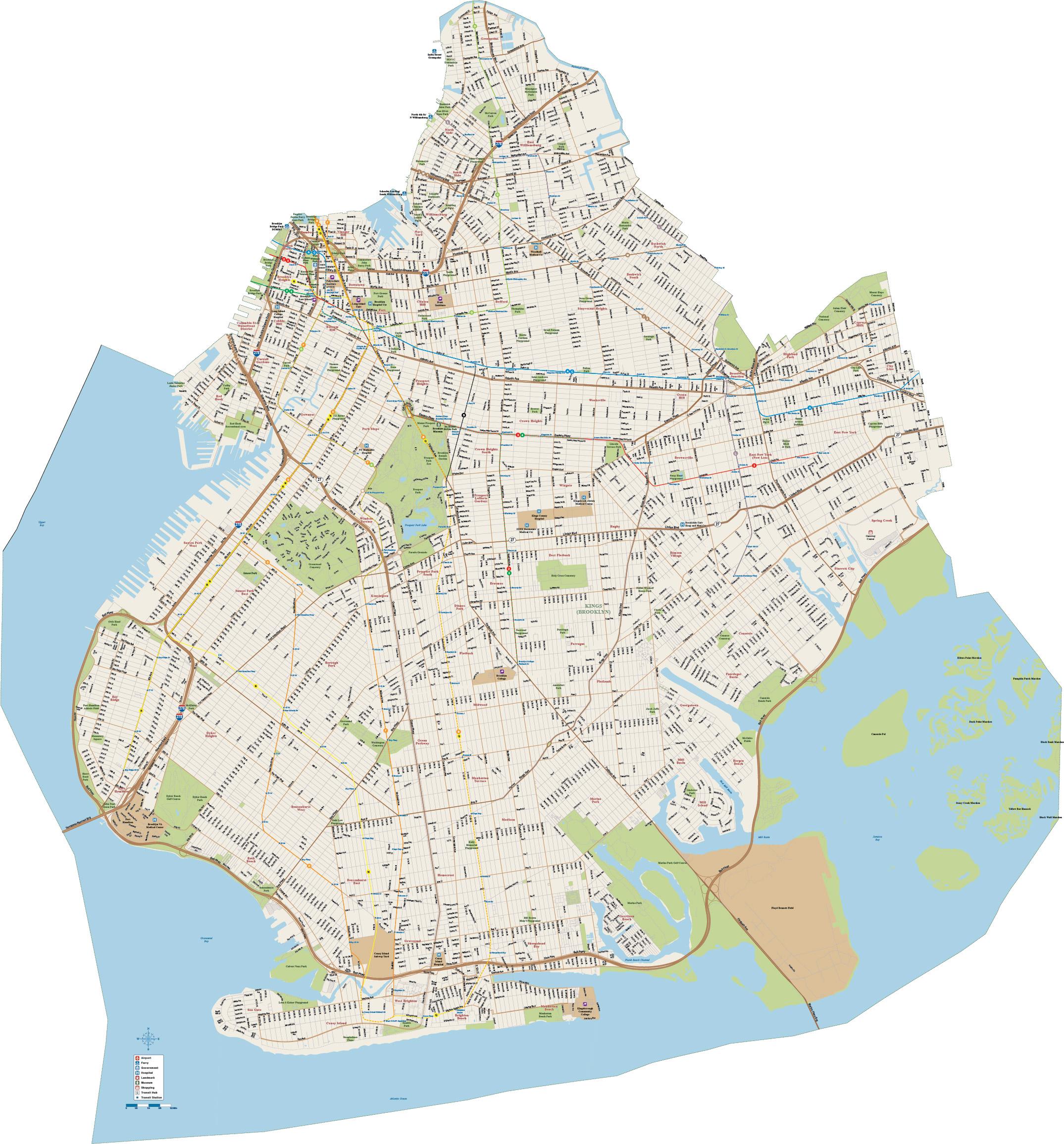
The Brooklyn streets map shows all street network and main roads of Brooklyn. This streets map of Brooklyn will allow you to find your routes through the streets of Brooklyn in New York - USA. The Brooklyn streets map is downloadable in PDF, printable and free.
Major thoroughfares include, Atlantic Avenue, Fourth Avenue, 86th Street, Kings Highway, Bay Parkway, Ocean Parkway, Eastern Parkway, Linden Boulevard, McGuiness Boulevard, Flatbush Avenue, Pennsylvania Avenue, and Bedford Avenue as you can see in Brooklyn streets map. Much of Brooklyn has only named streets, but Park Slope, Bay Ridge, Sunset Park, Bensonhurst, and Borough Park and the other western sections have numbered streets running approximately northwest to southeast, and numbered avenues going approximately northeast to southwest. East of Dahill Road, lettered avenues (like Avenue M) run east and west, and numbered streets have the prefix "East". South of Avenue O, related numbered streets west of Dahill Road use the "West" designation. This set of numbered streets ranges from West 37th Street to East 108 Street, and the avenues range from A-Z with names substituted for some of them in some neighborhoods (notably Albemarle, Beverley, Cortelyou, Dorchester, Ditmas, Foster, Farragut, Glenwood, Quentin).
The streets are offset by about 40 degrees from true east-west, that is they run southeast-northwest, but by local convention they are called east-west as its shown in Brooklyn streets map. With Brooklyn avenues, 1-28 they form a street grid. While similar to Manhattan grid, this Brooklyn grid does not have strict rules of traffic direction based on whether a street number is odd or even. This grid starts with 1st Street in Park Slope south of Garfield Place and ends with 101st Street just north of Shore Road and the Belt Parkway in Bay Ridge. On bustling Nostrand Avenue, you will find a combo of newer and mainstay businesses to stop by, like the jazz club Sistas Place, Korean burrito slinging neighborhood Wi-Fi stop Nostrand Cafe, and, just around the corner on Myrtle Avenue, Japanese restaurant 750 Myrtle Diner.
Franklin Street as its mentioned in Brooklyn streets map is where you can paw through the vintage jeans and jackets at Walk The West, taste natural wine at Dandelion Wine, grab a coffee and a succulent at Homecoming, and maybe sit down for some of New York best pancakes (served with a generous pat of butter) at Chez Ma Tante. Bedford Avenue is usually the street people think of when they envision Williamsburg. The longest street in Brooklyn, Bedford starts where Greenpoint ends, winding parallel to McCarren Park (Great dog watching! Great Saturday farmers market) and all the way down to Sheepshead Bay in South Brooklyn. Continue down Metropolitan Avenue or Grand Street, through East Williamsburg (the neighborhood between what is typically referred to as Williamsburg and its eastern neighbor, Bushwick) until you reach Flushing Avenue. Flushing intersects with Wyckoff and Irving, two main Bushwick avenues home to iconic locations like the edgy (sometimes sex) club House of Yes and local hangs like hipster coffee shop AP Cafe, the cheeky dive bar Boobie Trap, brewery and Basque-inspired restaurant Brooklyn Cider House, and vegan Ethiopian spot Bunna.

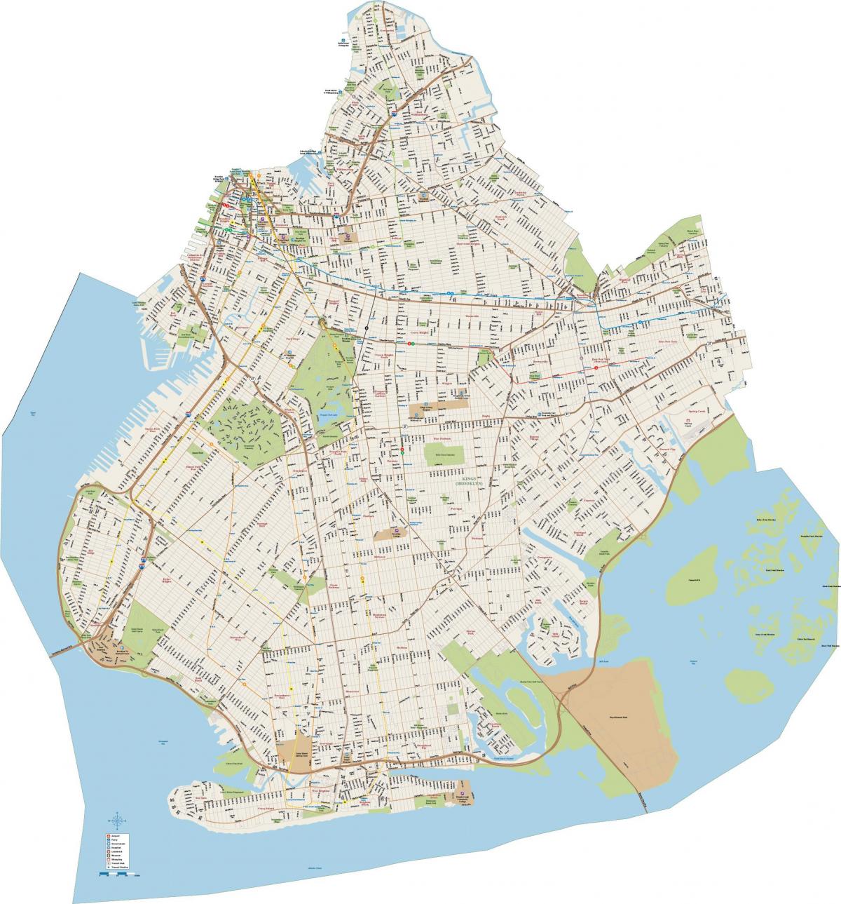
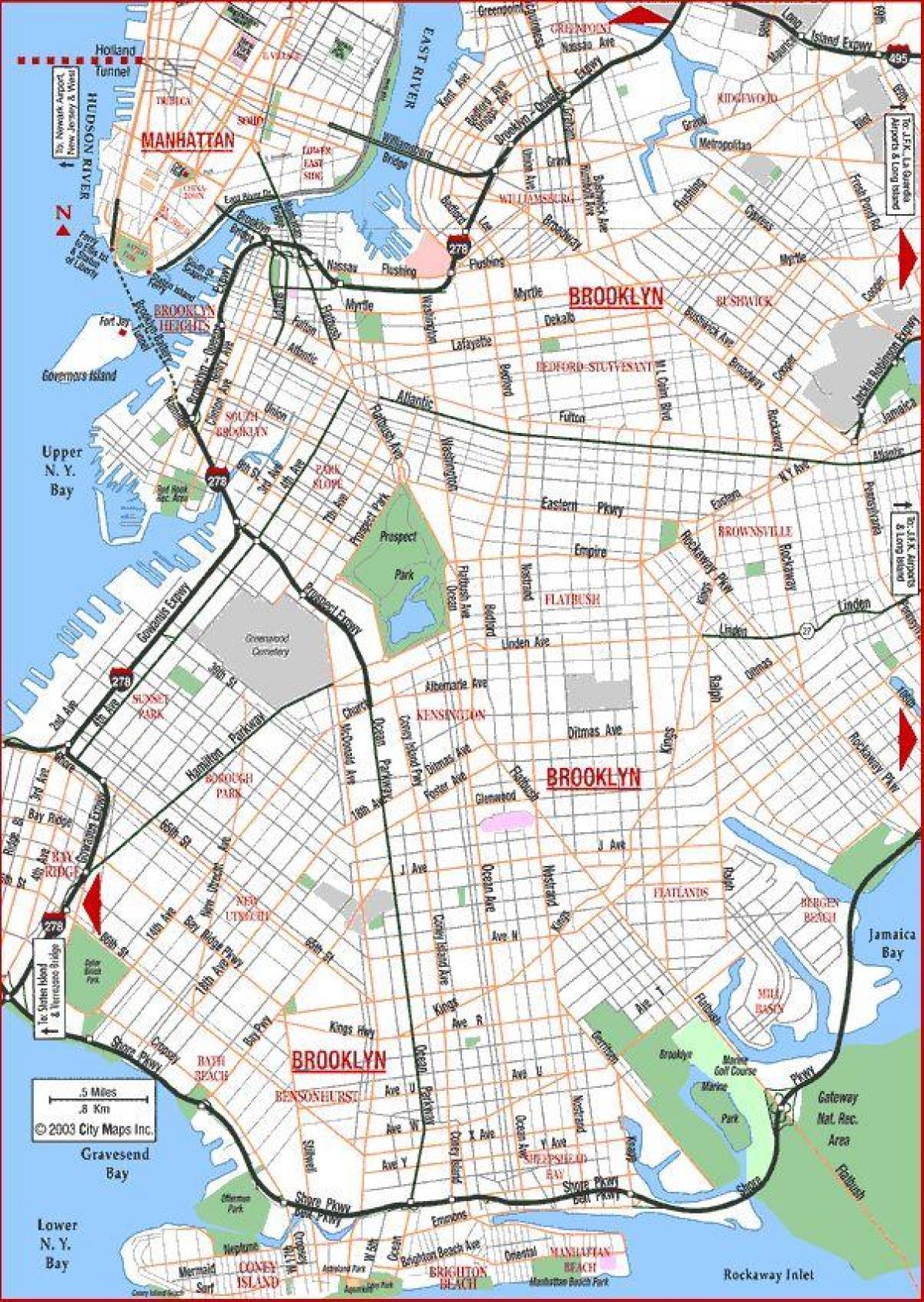
The Brooklyn roads map shows all road network and highways of Brooklyn. This roads map of Brooklyn will allow you to find your routes through the roads and motorways of Brooklyn in New York - USA. The Brooklyn roads map is downloadable in PDF, printable and free.
The great majority of limited-access expressways and parkways are located in the western and southern sections of Brooklyn. These include the Brooklyn-Queens Expressway, the Gowanus Expressway, which is part of the Brooklyn-Queens Expressway, the Prospect Expressway, New York State Route 27, the Belt Parkway, and the Jackie Robinson Parkway (formerly the Interborough Parkway) as you can see in Brooklyn roads map. Planned expressways that were never built include the Bushwick Expressway, an extension of I-78 and the Cross-Brooklyn Expressway, I-878. Major thoroughfares include, Atlantic Avenue, Fourth Avenue, 86th Street, Kings Highway, Bay Parkway, Ocean Parkway, Eastern Parkway, Linden Boulevard, McGuiness Boulevard, Flatbush Avenue, Pennsylvania Avenue, and Bedford Avenue.
Highway 252 and I-94 in Brooklyn Center, Brooklyn Park and north Minneapolis as its shown in Brooklyn roads map are in need of improvements and repairs . Currently, we are seeing a high number of crashes, traffic congestion, and significant barriers for pedestrians and bicyclists in the area. Both roads also are deteriorating and need to be repaired. Before we make any major improvements to Highway 252 and I-94, we are working closely with the public, and our federal and local partners to gain a better understanding of safety and transportation needs in the area. As part of this study, we also are taking a closer look at how a potential construction project could affect the environment surrounding Highway 252 and I-94.
In 1936, the Regional Plan Association recommended the construction of a link between the Gowanus Parkway and the Triborough Bridge as its mentioned in Brooklyn roads map. Originally, this plan was devised as an alternative to a competing plan for a proposed Brooklyn-Battery Bridge (which eventually opened as a tunnel in 1950), and included the reconstruction of the Williamsburg, Manhattan and Brooklyn bridges. The "Brooklyn-Queens Connecting Highway," which was to be financed by Federal, state and city funds, was proposed as an express bypass through heavily built industrial, commercial and residential areas. It was to also provide a link from Brooklyn and Queens points to the East River crossings.